https://www.emporis.com/state/100546/british-columbia-canada
https://www.emporis.com/city/100997/vancouver-canada/status/all-buildings
https://www.emporis.com/city/102437/burnaby-canada/status/all-buildings
https://www.emporis.com/city/101903/new-westminster-canada/status/all-buildings
https://www.emporis.com/city/103732/port-moody-canada/status/all-buildings
https://www.emporis.com/city/102600/coquitlam-canada/status/all-buildings
https://www.emporis.com/city/102083/richmond-canada/status/all-buildings
https://www.emporis.com/city/101002/surrey-canada/status/all-buildings
https://www.google.ca/search?q=tallest+buildings+in+surrey+bc&source=lnms&tbm=isch&sa=X&ved=0ahUKEwj3j9-HwajVAhWjjlQKHdSZCNwQ_AUICigB&biw=1530&bih=738
Showing posts sorted by relevance for query city. Sort by date Show all posts
Showing posts sorted by relevance for query city. Sort by date Show all posts
Wednesday, July 26, 2017
Tuesday, January 17, 2017
new-surrey-city-centre-plan-adopted


https://www.3civicplaza.ca

http://www.translink.ca/en/Plans-and-Projects/Station-and-Exchange-Improvements/Expo-Line-Upgrades/Surrey-Central-Station-Upgrades.aspx

https://urbansurrey.com/2017/01/14/concord-pacifics-final-park-place-tower-heading-to-council-jan-16 ,
http://www.centralcity.ca/about


http://www.centralcity.ca/directory

http://www.centralcity.ca/about/simon-fraser-university

Monday, November 28, 2016
burnaby malls


http://shapeproperties.com/our-places/city-lougheed
http://www.vancitybuzz.com/2016/03/lougheed-town-centre-redevelopment
http://vancouversun.com/life/homes/huge-city-of-lougheed-to-rise-on-40-acre-site-in-burnaby
http://www.tricitynews.com/news/city-of-lougheed-rises-next-door-1.2365281
https://www.burnaby.ca/City-Services/Policies--Projects---Initiatives/Community-Development/Community-Plans/Draft-Lougheed-Town-Centre-Core-Area-Master-Plan.html
https://www.google.ca/webhp?sourceid=chrome-instant&ion=1&espv=2&ie=UTF-8#q=city+of+lougheed
http://www.civitasdesign.com/station-square.html
Tuesday, December 13, 2016
Stumps vs Towers...
The Harbour Centre is located in downtown Vancouver, British Columbia and was completed in 1977. This building was designed by WZMH Architects and stands 581 feet tall with 28 floors.
http://replicabuildings.com/proddetail.php?prod=734 481' without the flagpole.
Commerce Court North is located at 25 King Street West in Toronto, Ontario and was completed in 1931. This building was designed by Pearson and Darling and stands 476 feet tall with 34 floors.
http://replicabuildings.com/proddetail.php?prod=725
First Canadian Place is located at 100 King Street West in Toronto, Ontario and was completed in 1975. This building was designed by Bregman + Hamann Architects and stands 978 feet tall with 72 floors.
http://replicabuildings.com/proddetail.php?prod=722
33 North LaSalle Street, Chicago, IL
http://replicabuildings.com/proddetail.php?prod=919 479' 38 floors
The former, Sears Tower
http://replicabuildings.com/proddetail.php?prod=730 1454 roof, 1729 Antenna 110 stories
The Mercantile Bank is located at 1700 Main Street in Dallas, Texas and was completed in 1943. This building was designed by Walter W. Ahlschlager and Donald Nelson and stands 523 feet tall with 31 floors.
http://replicabuildings.com/proddetail.php?prod=258
The Gulf Building is located at 712 Main Street in Houston, TX and was completed in 1929. This building was designed by Alfred C. Finn, Kenneth Franzheim and J. E. R. Carpenter and stands 428 feet tall with 36 floors.
http://replicabuildings.com/proddetail.php?prod=851
The Texas Commerce Tower is located at 600 Travis Street in Houston, TX and was completed in 1982. This building was designed by I.M. Pei and Partners and stands 1,002 feet tall with 75 floors. Texas Commerce Tower also known as JP Morgan Chase Tower is the tallest building in Houston and the tallest building in the state of Texas.
http://replicabuildings.com/proddetail.php?prod=553
LA City Hall is located at the civic center in Los Angeles and was completed in 1928. This building was designed by AC Martin Partners, Inc., Albert C. Martin, Sr. and John Parkinson and stands 454 feet tall with 32 floors. City Hall was the tallest building in California for 36 years (1928-1964)
http://replicabuildings.com/proddetail.php?prod=406
The Library Tower is located at 633 West Fifth Street in Los Angeles, California and was completed in 1990. This building was designed by Pei Cobb Freed & Partners and stands 1018 feet tall with 73 floors.
http://replicabuildings.com/proddetail.php?prod=318
The Russ Building is located at 235 Montgomery Street in San Francisco and was completed in 1927. This building was designed by George W. Kelham and stands 435 feet tall with 31 floors.
http://replicabuildings.com/proddetail.php?prod=625
555 California Street is located at 555 California Street in San Francisco, California and was completed in 1969. This building was designed by Skidmore, Owings & Merrill and Wurster, Bernardi & Emmons Architects and stands 779 feet tall with 52 floors. 555 California was once San Francisco’s tallest skyscraper, but was surpassed by the Transamerica Pyramid.
http://replicabuildings.com/proddetail.php?prod=289
The Philadelphia City Hall is located at Broad and Market Streets in Philadelphia, PA and was completed in 1901. This building was designed by John J. McArthur, Jr. and stands 548 feet tall with 9 floors. City Hall was designed to be the tallest structure on earth but due to the fact that it took 30 years to build, the Eiffel Tower and the Washington Monument eclipsed it. The statue of William Penn stands 37 feet high.
http://replicabuildings.com/proddetail.php?prod=488 511' not including the statue.
The Comcast Center is located at 1701 John F. Kennedy Blvd in Philadelphia, PA and was completed in 2008. This building was designed by Robert A. M. Stern Architects and stands 975 feet tall with 57 floors. Comcast is currently the tallest building in Philly.
http://replicabuildings.com/proddetail.php?prod=401
US Steel Tower is located at 600 Grant Street in Pittsburgh, PA and was completed in 1970. This building was designed by Harrison, Abramovitz & Abbe and stands 841 feet tall with 64 floors. This building is currently the tallest in Pittsburgh.
http://replicabuildings.com/proddetail.php?prod=548
The Koppers Building is located at 436 Seventh Avenue in Pittsburgh and was completed in 1929. This building was designed by Graham, Anderson, Probst & White and stands 475 feet tall with 34 floors.
http://replicabuildings.com/proddetail.php?prod=800
The Foshay Tower is located at 821 Marquette Avenue in Minneapolis, Minnesota and was completed in 1929. This building was designed by Magney & Tusler, Architects and stands 447 feet tall with 32 floors.
http://replicabuildings.com/proddetail.php?prod=68
The IDS Tower is located in the IDS Center in Minneapolis, MN and was completed in 1973. This building was designed by Edward F. Baker & Associates and Johnson/Burgee Architects and stands 792 feet tall with 55 floors. IDS in the tallest building in Minneapolis, it surpassed Foshay Tower which was the tallest since 1929.
http://replicabuildings.com/proddetail.php?prod=429
http://replicabuildings.com/proddetail.php?prod=734 481' without the flagpole.
Commerce Court North is located at 25 King Street West in Toronto, Ontario and was completed in 1931. This building was designed by Pearson and Darling and stands 476 feet tall with 34 floors.
http://replicabuildings.com/proddetail.php?prod=725
First Canadian Place is located at 100 King Street West in Toronto, Ontario and was completed in 1975. This building was designed by Bregman + Hamann Architects and stands 978 feet tall with 72 floors.
http://replicabuildings.com/proddetail.php?prod=722
33 North LaSalle Street, Chicago, IL
http://replicabuildings.com/proddetail.php?prod=919 479' 38 floors
The former, Sears Tower
http://replicabuildings.com/proddetail.php?prod=730 1454 roof, 1729 Antenna 110 stories
The Mercantile Bank is located at 1700 Main Street in Dallas, Texas and was completed in 1943. This building was designed by Walter W. Ahlschlager and Donald Nelson and stands 523 feet tall with 31 floors.
http://replicabuildings.com/proddetail.php?prod=258
The Gulf Building is located at 712 Main Street in Houston, TX and was completed in 1929. This building was designed by Alfred C. Finn, Kenneth Franzheim and J. E. R. Carpenter and stands 428 feet tall with 36 floors.
http://replicabuildings.com/proddetail.php?prod=851
The Texas Commerce Tower is located at 600 Travis Street in Houston, TX and was completed in 1982. This building was designed by I.M. Pei and Partners and stands 1,002 feet tall with 75 floors. Texas Commerce Tower also known as JP Morgan Chase Tower is the tallest building in Houston and the tallest building in the state of Texas.
http://replicabuildings.com/proddetail.php?prod=553
LA City Hall is located at the civic center in Los Angeles and was completed in 1928. This building was designed by AC Martin Partners, Inc., Albert C. Martin, Sr. and John Parkinson and stands 454 feet tall with 32 floors. City Hall was the tallest building in California for 36 years (1928-1964)
http://replicabuildings.com/proddetail.php?prod=406
The Library Tower is located at 633 West Fifth Street in Los Angeles, California and was completed in 1990. This building was designed by Pei Cobb Freed & Partners and stands 1018 feet tall with 73 floors.
http://replicabuildings.com/proddetail.php?prod=318
The Russ Building is located at 235 Montgomery Street in San Francisco and was completed in 1927. This building was designed by George W. Kelham and stands 435 feet tall with 31 floors.
http://replicabuildings.com/proddetail.php?prod=625
555 California Street is located at 555 California Street in San Francisco, California and was completed in 1969. This building was designed by Skidmore, Owings & Merrill and Wurster, Bernardi & Emmons Architects and stands 779 feet tall with 52 floors. 555 California was once San Francisco’s tallest skyscraper, but was surpassed by the Transamerica Pyramid.
http://replicabuildings.com/proddetail.php?prod=289
The Philadelphia City Hall is located at Broad and Market Streets in Philadelphia, PA and was completed in 1901. This building was designed by John J. McArthur, Jr. and stands 548 feet tall with 9 floors. City Hall was designed to be the tallest structure on earth but due to the fact that it took 30 years to build, the Eiffel Tower and the Washington Monument eclipsed it. The statue of William Penn stands 37 feet high.
http://replicabuildings.com/proddetail.php?prod=488 511' not including the statue.
The Comcast Center is located at 1701 John F. Kennedy Blvd in Philadelphia, PA and was completed in 2008. This building was designed by Robert A. M. Stern Architects and stands 975 feet tall with 57 floors. Comcast is currently the tallest building in Philly.
http://replicabuildings.com/proddetail.php?prod=401
US Steel Tower is located at 600 Grant Street in Pittsburgh, PA and was completed in 1970. This building was designed by Harrison, Abramovitz & Abbe and stands 841 feet tall with 64 floors. This building is currently the tallest in Pittsburgh.
http://replicabuildings.com/proddetail.php?prod=548
The Koppers Building is located at 436 Seventh Avenue in Pittsburgh and was completed in 1929. This building was designed by Graham, Anderson, Probst & White and stands 475 feet tall with 34 floors.
http://replicabuildings.com/proddetail.php?prod=800
The Foshay Tower is located at 821 Marquette Avenue in Minneapolis, Minnesota and was completed in 1929. This building was designed by Magney & Tusler, Architects and stands 447 feet tall with 32 floors.
http://replicabuildings.com/proddetail.php?prod=68
The IDS Tower is located in the IDS Center in Minneapolis, MN and was completed in 1973. This building was designed by Edward F. Baker & Associates and Johnson/Burgee Architects and stands 792 feet tall with 55 floors. IDS in the tallest building in Minneapolis, it surpassed Foshay Tower which was the tallest since 1929.
http://replicabuildings.com/proddetail.php?prod=429
Friday, November 27, 2020
centuries-of-weather-impacts-leave-ancient-city-of-shibam-on-the-brink-of-collapse
https://www.archdaily.com/771154/the-manhattan-of-the-desert-shibam-yemens-ancient-skyscraper-city
https://www.businessinsider.com/photos-show-shibam-yemen-as-ancient-city-crumbles-2019-10
https://www.nationalgeographic.com/travel/destinations/asia/yemen/shibam-mud-skyscraper-yemen/
https://www.aljazeera.com/gallery/2020/11/10/in-pictures-yemens-ancient-manhattan-of-the-desert/
Saturday, September 22, 2018
Where is the world's most remote city?
https://www.theguardian.com/cities/2015/aug/19/where-worlds-most-remote-city
Anchorage,_Alaska is the largest northern US city.
Edmonton is the largest northern Canadian city.
Thursday, October 9, 2025
Brisbane vs. Vancouver
https://en.wikipedia.org/wiki/Brisbane
https://en.wikipedia.org/wiki/Brisbane_Skytower
| Roof | 269.6 m (885 ft) |
|---|---|
| Technical details | |
| Floor count | 90 |
https://en.wikipedia.org/wiki/Brisbane_Skytower#Design_and_location
Brisbane can have a building 30 floors taller than the Living_Shangri-La in Vancouver, because it doesn't have Vancouver's imposed restrictions. https://en.wikipedia.org/wiki/Living_Shangri-La
https://en.wikipedia.org/wiki/Brisbane#Transport
https://en.wikipedia.org/wiki/Brisbane_Airport#Rail Unlike Vancouver, Brisbane has long trains, as most real cities do.
https://en.wikipedia.org/wiki/Sir_Leo_Hielscher_Bridges#Duplication A 12 lane crossing.
https://en.wikipedia.org/wiki/George_Massey_Tunnel The 4 lane tunnel should have been twinned or duplicated by 1980. Then a parallel bus and train tunnel or bridge by around 2000-2010.
https://www.infrastructurebc.com/project/fraser-river-tunnel-project A wattered down 8 lane BC crossing. Even by 2030, there still won't be a train and HOV tunnel or bridge.
https://www.infrastructurebc.com/project/roberts-bank-terminal-2-landmass-and-wharf-project A slow, constipated planning an developing process in backwards BC. It was the total opposite for the Port_of_Brisbane. https://en.wikipedia.org/wiki/Port_of_Brisbane
https://en.wikipedia.org/wiki/World_Expo_88#The_Fair Brisbane was able to grow into a big bustling city with taller buildings, longer trains, wider bridges and more tunnels than restrictive, backwards Vancouver.
https://en.wikipedia.org/wiki/Expo_86#Fair Unfortunately, Vancouver doubled down on being a watered down, provincial city. Brisbane just never had the overlapping imposed restrictions that Vancouver has.
https://en.wikipedia.org/wiki/Airport_railway_line,_Brisbane#Criticism At least Brisbane and Perth allowed for enough clearance to have longer stations and trains than backwards Vancouver. Running longer trains more frequently is better than the Vancouver short train mentality.
The Canada_Line wasn't designed to be like a proper big city train. The stations are only an absurd 50 m when the Montreal Metro has 152.5 m stations. Montreal has 9 car trains, but Vancouver never allowed for future clearance to accomodate 8-10 car trains. Not even a 5 car train was allowed in the cost-cutting design. The Canada_Line is a totally intentional embarrassment in urban planning. Why design stations to accomodate a 10 car or at least a 5 car train, when a 2.5 car joke of a train can provide more congestion?
https://en.wikipedia.org/wiki/SkyTrain_(Vancouver)#Network Its taken until 2025 for the first line to start running 5 car trains. Eventually, the 2nd line will also start to have 5 car trains.
https://en.wikipedia.org/wiki/SkyTrain_(Vancouver)#Canada_Line The (embarrassment) Line has yet to start running a 2.5 car train. https://en.wikipedia.org/wiki/SkyTrain_(Vancouver)#Rolling_stock It's so sad and pathetic that all 3 lines weren't designed to start with 5 car trains and gradually run 10 car trains.
In Vancouver, short trains, mostly narrow bridges and short buildings, all fit in with the symbolic reluctance to build proper big city size infrastructure. Who knows where the money went, because it sure didn't go into the scaled back or watered down BC infrastructure?
South_East_Queensland just like, Perth and especially, Melbourne & Sydney were able to unlock their various restrictions decades ago. Where as the backwards BC Lower_Mainland and Vancouver_Island still have so much red tape and overlapping restrictions.
https://en.wikipedia.org/wiki/South_East_Queensland#Attractions
https://en.wikipedia.org/wiki/Lower_Mainland#Regional_districts
Fortunately, the backwards BC mind virus hasn't spread to most of the world.
Thursday, February 18, 2021
Landmark Trump casino demolished in Atlantic City controlled explosion
https://en.wikipedia.org/wiki/Trump_Plaza_Hotel_and_Casino
https://en.wikipedia.org/wiki/Trump_Plaza_Hotel_and_Casino#Decline_and_demolition
https://www.cbc.ca/player/play/1862897219972
Saturday, April 14, 2018


Sunday, July 17, 2016
THE CITY OF LOUGHEED

https://en.wikipedia.org/wiki/Lougheed_Town_Centre_station
http://www.vancitybuzz.com/2016/03/lougheed-town-centre-redevelopment
https://www.burnaby.ca/City-Services/Policies--Projects---Initiatives/Community-Development/Community-Plans/Draft-Lougheed-Town-Centre-Core-Area-Master-Plan.html
http://www.burnabynow.com/news/a-tale-of-two-mall-sites-as-burnaby-redevelops-1.1978758
http://www.evergreenline.gov.bc.ca/documents/informationsheets/130607_lougheedtownctrstation.pdf
https://en.wikipedia.org/wiki/SkyTrain_(Vancouver)#Evergreen_Extension_.282017.29
https://en.wikipedia.org/wiki/Coquitlam_Centre#Transportation
Monday, December 14, 2015
Perth, Wa
http://skyrisecities.com/news/2015/11/woods-bagot-unveils-towers-perths-city-link-district
 http://www.pta.wa.gov.au/perthcitylink/PlatformIssue1/HistoricAllianceReadytoDeliver/tabid/379/language/en-AU/Default.aspx
http://aerialphotographywa.com/perth-city-link-sinking-the-fremantle-line-northbridge/
http://www.mra.wa.gov.au/projects-and-places/perth-city-link/vision
https://www.google.ca/search?q=The+new+Fremantle+Line+rail+tunnel&safe=off&tbm=isch&tbo=u&source=univ&sa=X&ved=0ahUKEwic0eb8mNvJAhVS6GMKHbGBDVoQsAQINA&biw=2133&bih=1078&dpr=0.9
https://www.google.ca/search?q=The+new+Fremantle+Line+rail+tunnel&oq=The+new+Fremantle+Line+rail+tunnel&aqs=chrome..69i57&sourceid=chrome&es_sm=93&ie=UTF-8
http://skyscraperpage.com/diagrams/?stateID=47&status=15 wa
http://skyscraperpage.com/diagrams/?countryID=8&status=15 aus
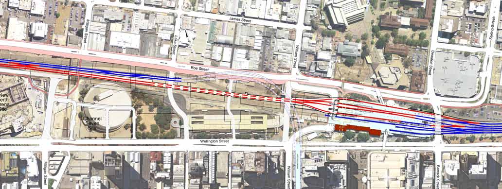
http://aerialphotographywa.com/perth-city-link-sinking-the-fremantle-line-northbridge/
http://www.mra.wa.gov.au/projects-and-places/perth-city-link/vision
https://www.google.ca/search?q=The+new+Fremantle+Line+rail+tunnel&safe=off&tbm=isch&tbo=u&source=univ&sa=X&ved=0ahUKEwic0eb8mNvJAhVS6GMKHbGBDVoQsAQINA&biw=2133&bih=1078&dpr=0.9
https://www.google.ca/search?q=The+new+Fremantle+Line+rail+tunnel&oq=The+new+Fremantle+Line+rail+tunnel&aqs=chrome..69i57&sourceid=chrome&es_sm=93&ie=UTF-8
http://skyscraperpage.com/diagrams/?stateID=47&status=15 wa
http://skyscraperpage.com/diagrams/?countryID=8&status=15 aus
Tuesday, October 18, 2016
LGB
New Burrard Inlet crossing options
TransLink’s Mayors’ Council’s $7.5-billion, 10-year transportation plan, which is currently being decided by the region’s voters, does not account for the need of additional road capacity to the North Shore.
The Lions Gate Bridge and Stanley Park Causeway are under the jurisdiction of the provincial government. Any improvements or a replacement would have to be spearheaded and largely funded by the provincial government, as in the cases of the new Port Mann Bridge, Highway 1 expansion, South Fraser Perimeter Road, and the upcoming George Massey Tunnel replacement project.
There have been at least half a dozen proposals to build an undersea tunnel to the North Shore, with the oldest proposal dating back to 1890s.
A more serious proposal was fronted in the 1960s and 1970s when the provincial government pushed a plan to build a network of freeways that criss-crossed the city’s waterfront. With the exception of the Granville Street Bridge and the Georgia and Dunsmuir viaducts, the freeway plan never saw daylight due to municipal-level opposition.
One Danish proposal in the 1990s even called for a land reclamation project in Burrard Inlet at the location of the midway point of the bored tunnel. Condominium towers would be built on the island to help fund the construction of the project.
In the late-1990s, Glen Clark’s provincial government proposed a plan to refit and expand the rusting 1930s-built Lions Gate Bridge. The original plan called for a replacement and expansion of the bridge deck from three lanes to four lanes, eliminating the need for a counterflow traffic system.
But elected officials in Vancouver City Council and the Park Board opposed the plan, given that that a significantly greater number of trees would have to be cut down along the causeway.
Shortly after the Lions Gate Bridge refit project was complete, in 2002 a proposal emerged to construct a six-kilometre long tunnel from the foot of Main Street in Vancouver to the North Shore.
From Vancouver, the route would traverse northwest under Coal Harbour, pass by the area just north of Brockton Point, and end at Taylor Way in West Vancouver to provide a direct and more efficient connection with the Upper Levels Highway. The depth of Burrard Inlet along this tunnelled route option is relatively shallow, ranging from 40 metres to 75 metres.
Like in many other major cities, this 2002 proposal will enable commuters to bypass the street grid and local traffic of the downtown core.
Traffic from the existing Lions Gate Bridge configuration, used by about 70,000 vehicles every weekday, already causes severe congestion in downtown streets and increasingly spills into West End neighbourhood streets.
Any crossing replacement or expansion option would have to consider the reality that downtown Vancouver’s street grid does not possess the capacity to handle a significant increase in vehicle traffic volume. This could be further exacerbated by the City’s plan to demolish the Georgia and Dunsmuir viaducts, which will redirect traffic to other adjacent arterial streets.
http://www.vancitybuzz.com/2015/04/lions-gate-bridge-close-vehicle-traffic-2030-government-agreement/
Subscribe to:
Posts (Atom)